A Category 5 atmospheric river - NorthWest US
Page 1 of 1 • Share
 A Category 5 atmospheric river - NorthWest US
The Pacific Northwest is known for rain, but not this much.
So far this year, Seattle has seen nearly 6.5" of rain. With an additional 2-4 inches forecast, the city could receive roughly 25% of its annual rainfall by January 15 from the atmospheric river that's drenching the region.
"This soggy start could propel Seattle to its single wettest start of any year on record. The previous wettest Jan 1-15 period occurred in January 1956, when nearly 7 inches fell in the first half the month," says CNN meteorologist Pedram Javaheri.
Atmospheric rivers are long, narrow regions in the atmosphere -- like rivers in the sky -- that transport water vapor, according to the National Oceanic and Atmospheric Administration.
This atmospheric river event is being classified as a Category 5 -- the highest level -- from the Center for Western Weather and Water Extremes. The flooding potential is huge, with roughly 15 million people under some sort of watch or advisory. Parts of western Washington could see 300% of normal rainfall, according to the Weather Prediction Center.
"Soil saturation levels are ranging from 75-95% along the western third of the region right now. It won't take much rainfall to lead to surface flooding," says Javaheri.
There's also plenty of warmth in the mid-levels of the atmosphere during this particular atmospheric river event. This will raise snow levels on elevations above 6,000 feet across much of the Cascades, with rain falling below that level.
"This will further exacerbate flooding concerns as heavy rain falls atop abundant snow. The threat for rapid melting, increased runoff and downstream river flooding is something everyone in western Oregon and Washington should be on alert for," says Javaheri.
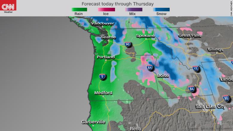
Higher elevations in Washington could see 2 inches to 4 inches of rain during the next 24 hours, increasing the flooding and landslide risk.

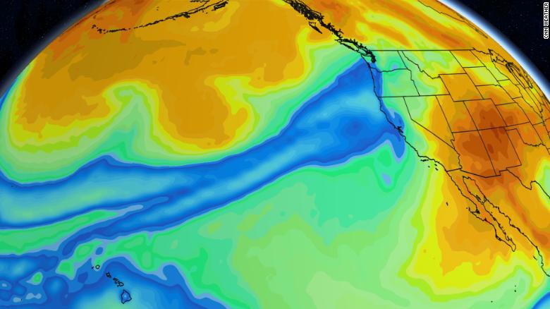
Forecast models show the moisture - shown in blue - stretching thousands of miles.
Rainfall at lower elevations should be between 1 and 2 inches during that time.
In Portland, Oregon, the National Weather Service Office has forecast up to 7 inches of rain in the higher terrain and up to 2 inches for the lowlands through Wednesday morning. Along with that, there's a high-wind warning in effect.

Two to four inches of additional rainfall is possible for the Pacific Northwest
Wind warnings extend along the whole Oregon coastline, where gusts could reach up to 75 mph. This raises concerns for downed trees, power outages and possible hazards along Interstate 5.
The impacts from the record-setting wildfires are also raising the threats of flooding for Oregon. According to the Oregon Department of Forestry, more than 1 million acres burned. These burn scars that remain make the flood threat even greater, due to charred ground with no vegetation to soak up the rainwater. This enhances the possibility of flash flooding and landslides due to the loose terrain.
So far this year, Seattle has seen nearly 6.5" of rain. With an additional 2-4 inches forecast, the city could receive roughly 25% of its annual rainfall by January 15 from the atmospheric river that's drenching the region.
"This soggy start could propel Seattle to its single wettest start of any year on record. The previous wettest Jan 1-15 period occurred in January 1956, when nearly 7 inches fell in the first half the month," says CNN meteorologist Pedram Javaheri.
Atmospheric rivers are long, narrow regions in the atmosphere -- like rivers in the sky -- that transport water vapor, according to the National Oceanic and Atmospheric Administration.
Flooding concern for 15 million people
This atmospheric river event is being classified as a Category 5 -- the highest level -- from the Center for Western Weather and Water Extremes. The flooding potential is huge, with roughly 15 million people under some sort of watch or advisory. Parts of western Washington could see 300% of normal rainfall, according to the Weather Prediction Center.
"Soil saturation levels are ranging from 75-95% along the western third of the region right now. It won't take much rainfall to lead to surface flooding," says Javaheri.
There's also plenty of warmth in the mid-levels of the atmosphere during this particular atmospheric river event. This will raise snow levels on elevations above 6,000 feet across much of the Cascades, with rain falling below that level.
"This will further exacerbate flooding concerns as heavy rain falls atop abundant snow. The threat for rapid melting, increased runoff and downstream river flooding is something everyone in western Oregon and Washington should be on alert for," says Javaheri.
Higher elevations in Washington could see 2 inches to 4 inches of rain during the next 24 hours, increasing the flooding and landslide risk.

Forecast models show the moisture - shown in blue - stretching thousands of miles.
Rainfall at lower elevations should be between 1 and 2 inches during that time.
In Portland, Oregon, the National Weather Service Office has forecast up to 7 inches of rain in the higher terrain and up to 2 inches for the lowlands through Wednesday morning. Along with that, there's a high-wind warning in effect.

Two to four inches of additional rainfall is possible for the Pacific Northwest
Wind warnings extend along the whole Oregon coastline, where gusts could reach up to 75 mph. This raises concerns for downed trees, power outages and possible hazards along Interstate 5.
The impacts from the record-setting wildfires are also raising the threats of flooding for Oregon. According to the Oregon Department of Forestry, more than 1 million acres burned. These burn scars that remain make the flood threat even greater, due to charred ground with no vegetation to soak up the rainwater. This enhances the possibility of flash flooding and landslides due to the loose terrain.
_________________


8DonCo
 Similar topics
» Historic Northwest heat wave linked to dozens of deaths
» River Cruise
» Hurricane Ida strengthens into Category 4 storm as it nears Gulf Coast
» Montana building falling into the swollen Yellowstone River
» SUNSHINE CRYSTAL RIVER – ĐẲNG CẤP DÀNH RIÊNG CHO GIỚI THƯỢNG LƯU
» River Cruise
» Hurricane Ida strengthens into Category 4 storm as it nears Gulf Coast
» Montana building falling into the swollen Yellowstone River
» SUNSHINE CRYSTAL RIVER – ĐẲNG CẤP DÀNH RIÊNG CHO GIỚI THƯỢNG LƯU
Page 1 of 1
Permissions in this forum:
You cannot reply to topics in this forum
 Home
Home