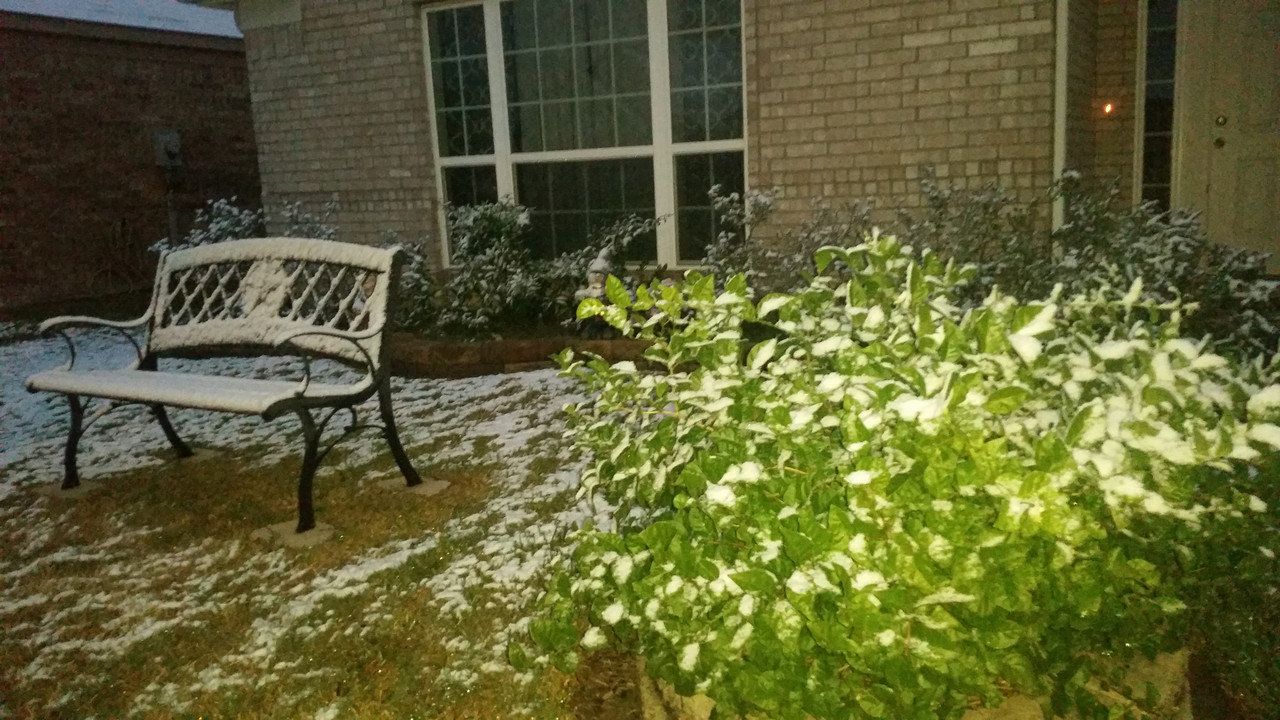
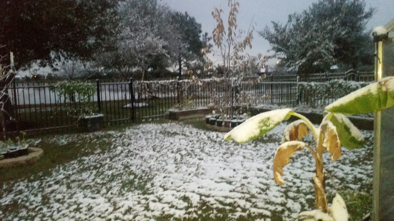
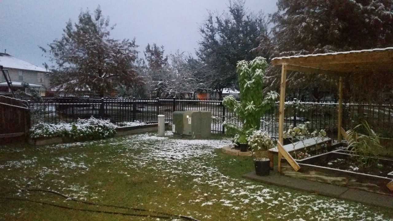
SNOW to blanket the South
Page 1 of 1 • Share
 SNOW to blanket the South
A significant winter storm will take shape beginning Friday over the Southern Plains and Texas, then spread this weekend through the Southeast and Mid-Atlantic.
How far south freezing air will reach remains an open question, making it difficult to precisely forecast ice and snow accumulation.
Winter storm watches are already in place Thursday for 6 million people in northern Texas, Oklahoma and parts of Arkansas and Missouri.
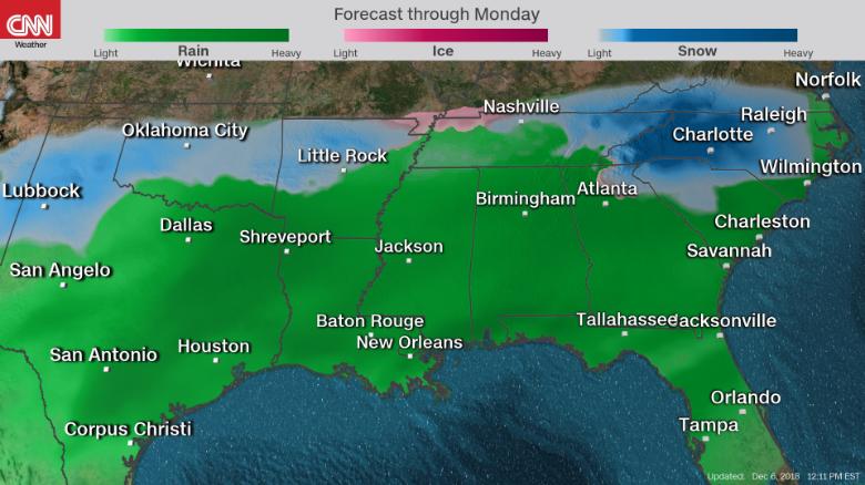
As the storm develops, forecast models will more accurately predict the freezing line and thus the type of precipitation places will experience, CNN meteorologist Brandon Miller said.
Here is what CNN meteorologists expect, where and when:
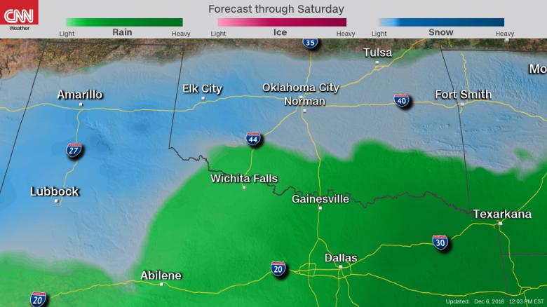
Timing: Friday morning through Saturday evening
Impacts: Flooding rain, ice and snow
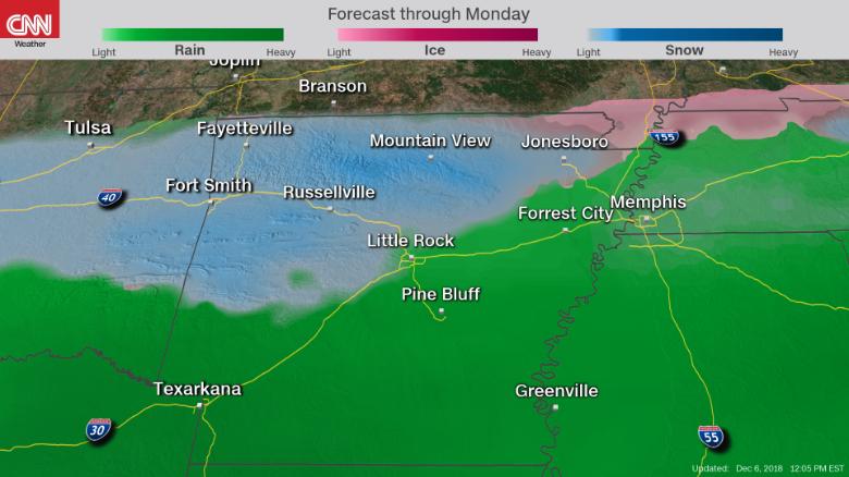
Timing: Friday afternoon through Saturday
Impacts: Flooding rains, wintry mix, mountain snow
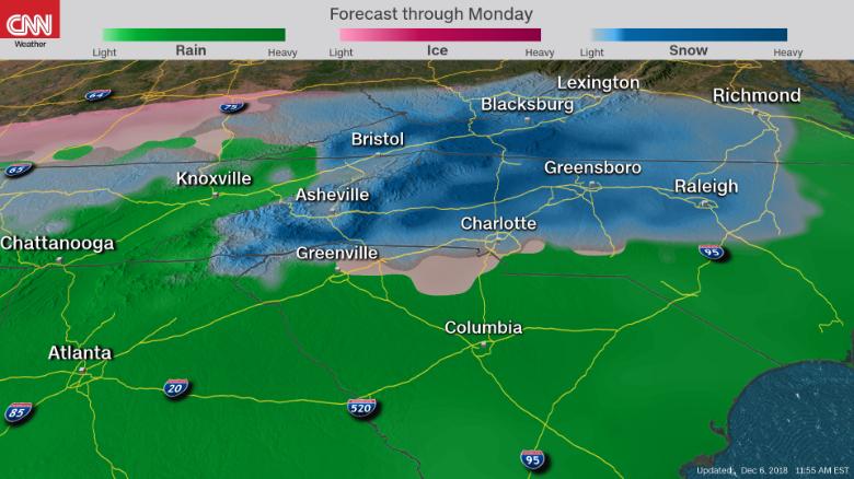
Timing: Saturday morning through Monday morning
Impacts: Record snow, blizzard conditions, wintry mix
A significant amount of snow across the mountains of North Carolina, South Carolina and northeast Georgia is expected but not certain.
If warmer air mixes in, it could lessen the amount of snow that accumulates. It all depends on a regional weather phenomenon called "cold-air damming" -- when cold air is forced from the northeast and pushes against the Appalachians. The mountain range acts as a dam, keeping the cold air pooled like a lake.
This shallow layer of cold air allows for freezing temperatures to remain near the surface as warmer, moist air moves over it. If the air column stays cold enough near the surface and extends high enough into the atmosphere, moisture will fall as snow. If air above freezing gets into the middle layer, there is a greater chance for ice pellets or even a wintry mix.
Right now, most forecast models show this lasting through the weekend and into early Monday.
The amount of snow in areas east of I-85 largely depends on how established the cold-air damming, also called "the wedge" in this region, becomes.
"(We) will hold of(f) on getting too cute with any snow amounts at this time given the degree of uncertainty and how the varying p(recipitation) types would impact accumulations," the National Weather Service in Raleigh said Thursday.
While most models keep the winter precipitation tucked into Carolinas, there is one model that shows the possibility of freezing rain reaching down the I-85 corridor to impact Atlanta on Sunday night into Monday.
The storm moves out to sea Monday, models showed Thursday. It also could turn and climb up the East Coast, bringing heavy snow to major metro areas, though this seems unlikely.
How far south freezing air will reach remains an open question, making it difficult to precisely forecast ice and snow accumulation.
Winter storm watches are already in place Thursday for 6 million people in northern Texas, Oklahoma and parts of Arkansas and Missouri.

As the storm develops, forecast models will more accurately predict the freezing line and thus the type of precipitation places will experience, CNN meteorologist Brandon Miller said.
Here is what CNN meteorologists expect, where and when:
Texas and Oklahoma

Timing: Friday morning through Saturday evening
- The primary precipitation will begin Friday, with freezing rain and drizzle in the panhandles of Texas and Oklahoma and possibly into central Oklahoma. The main winter weather impacts will occur late Friday, with a quick transition from a wintry mix to snow after midnight Friday for places including Oklahoma City.
- Precipitation in eastern Oklahoma won't turn to snow until later Saturday.
Impacts: Flooding rain, ice and snow
- Ice accumulations in Texas and Oklahoma could reach one-quarter to one-half inch, respectively.
- Snowfall in these areas could also top 6 inches. Expect dangerous travel conditions and power outages.
- Oklahoma City is expected to get one-10th to one-quarter of an inch of ice, plus 4 to 6 inches of snow.
- Tulsa, Oklahoma, will see less ice and snow, with ice accumulations near one-10th of an inch and snow of 2 to 3 inches.

- In Texas, the wintry weather will stay in the panhandle and the Red River Valley.
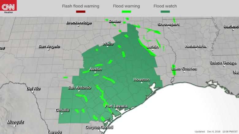
- Large amounts of rain will impact major Texas cities, including Dallas and Houston.
- More than 13 million people are under a flood or flash flood watch in eastern Texas. Cities like San Antonio and Houston could see flash flooding as rainfall total could reach 3 to 6 inches and isolated spots could see as much as 10 inches.
Arkansas and western Tennessee

Timing: Friday afternoon through Saturday
- Most of Arkansas won't feel the precipitation until later Friday, with some rain early in the south and central portions of the state.
- Winter weather won't begin until the overnight hours and will transition eastward Saturday morning.
Impacts: Flooding rains, wintry mix, mountain snow
- The southern half of Arkansas will get caught up in a similar situation as East Texas, with flash flooding possible. The Arkansas-Louisiana-Texas region could see 4 to 5 inches of rain.
- Winter precipitation will be likely on Saturday morning and through the day Saturday in Arkansas and western Tennessee, mostly north of Interstate 40.
- One forecast model shows colder air filtering a bit further south, potentially impacting Little Rock, Arkansas, and Memphis.
- Right now, Little Rock looks like it will pick up a maximum 1 inch, with little or no accumulation possible. Fayetteville and Bentonville, in Arkansas, meantime, will see 3 to 4 inches. In the higher elevations of the Ozark Mountains, 6 to 8 inches of snow is possible on top of a small glaze of ice to one-quarter inch.
- Snow totals will be lower in northeastern Arkansas and northwestern Tennessee, where 1 to 2 inches is possible.
Eastern Tennessee, northern Georgia and the Carolinas

Timing: Saturday morning through Monday morning
- Precipitation begins to creep into the region early Saturday morning, with rain in Georgia and some light, wintry precipitation in the mountains.
- From there, things get interesting. The situation will begin to pick up Saturday afternoon, with larger accumulations Sunday into early Monday morning.
Impacts: Record snow, blizzard conditions, wintry mix
A significant amount of snow across the mountains of North Carolina, South Carolina and northeast Georgia is expected but not certain.
If warmer air mixes in, it could lessen the amount of snow that accumulates. It all depends on a regional weather phenomenon called "cold-air damming" -- when cold air is forced from the northeast and pushes against the Appalachians. The mountain range acts as a dam, keeping the cold air pooled like a lake.
This shallow layer of cold air allows for freezing temperatures to remain near the surface as warmer, moist air moves over it. If the air column stays cold enough near the surface and extends high enough into the atmosphere, moisture will fall as snow. If air above freezing gets into the middle layer, there is a greater chance for ice pellets or even a wintry mix.
Right now, most forecast models show this lasting through the weekend and into early Monday.
- Early snow estimates range from 1 foot to almost 2 feet across the mountains and foothills west of Interstate 85.
- This means portions of North Carolina could see record snowfall. "This could be a once-in-a-generation event for areas that experience mostly snow and ice," the National Weather Service in Greenville, South Carolina, said Thursday.
- There is even the possibility on Sunday afternoon for blizzard conditions in the higher elevations of the Appalachians.
- North Carolina cities impacted by wintry precipitation will be Asheville, Greensboro, Raleigh and Charlotte.
The amount of snow in areas east of I-85 largely depends on how established the cold-air damming, also called "the wedge" in this region, becomes.
"(We) will hold of(f) on getting too cute with any snow amounts at this time given the degree of uncertainty and how the varying p(recipitation) types would impact accumulations," the National Weather Service in Raleigh said Thursday.
While most models keep the winter precipitation tucked into Carolinas, there is one model that shows the possibility of freezing rain reaching down the I-85 corridor to impact Atlanta on Sunday night into Monday.
The storm moves out to sea Monday, models showed Thursday. It also could turn and climb up the East Coast, bringing heavy snow to major metro areas, though this seems unlikely.
_________________


8DonCo
 Re: SNOW to blanket the South
_________________
Nếu ai hỏi vì sao yêu màu tím
Tôi trả lời vì tím rất thuỷ chung

Wenn- Location : Nơi Bình Yên Chim Hót
 Re: SNOW to blanket the South
Wenn wrote:Miền bắc TX thường bị trước. Chỗ tui hong xi nhê, cùng lắm là như vầy :
Dec8, 2017
vái nó xuống 1,2 inches thì đươc nghĩ làm

_________________


8DonCo
 Re: SNOW to blanket the South
Tui lại khoái làm, ở nhà 888 hong được. Ở nhà ci' bày trò nấu ăn cho mập thây thêm. Nếu ước được nghỉ làm, thì ước trời vẫn đẹp đi ra biển câu cá.


_________________
Nếu ai hỏi vì sao yêu màu tím
Tôi trả lời vì tím rất thuỷ chung

Wenn- Location : Nơi Bình Yên Chim Hót
 Re: SNOW to blanket the South
Coi news thấy snow storm move về hướng TX, Carolinas và VA nhiều, bà Gà có bày ra nấu gì không vậy ?

May4phuong
 Re: SNOW to blanket the South
NO SNOW in BOSTON yet  )........nhưng rất là lạnh
  )
)
Super Lạnh......hồi tối sau khi tech tennis xong đi ra xe OMG.......quá lạnh.....
tech,
Super Lạnh......hồi tối sau khi tech tennis xong đi ra xe OMG.......quá lạnh.....
tech,
Last edited by tech on Fri Dec 07, 2018 10:07 pm; edited 1 time in total
_________________

Love This Backhand & Backhand Slice

tech
 Re: SNOW to blanket the South
Ở VA hỗm rày cold front cũng tới. Nghe Gà con nói thứ 2 có thể tuyết nhưng sao coi weather.com thì 0 thấy nói gì hết. Chắc vài hôm nửa mới biết chắc cái storm này có lên tới VA hay không quá. Hiện giờ thì nó chỉ tới Roanoake là vùng núi gần VA Tech thôi.

ga10
 Re: SNOW to blanket the South
No snow ở đây nhưng mà mưa lạnh lẻo mưa kiểu này chỉ có nằm ngủ là sướng nhứt 

dakao2- Location : TX
 Re: SNOW to blanket the South
A major storm is threatening an earlier-than-usual wintry stew of snow, ice and flooding across parts of the Southern United States over the next few days.
More than 20 million people are under winter storm watches and warnings from New Mexico to North Carolina, where authorities have declared a statewide emergency as some areas could get over a foot of snow.
"Snow may be beautiful but it can also be treacherous and I urge North Carolinians to take this storm seriously and get ready for it now," Gov. Roy Cooper said in a statement.
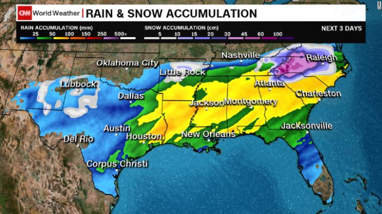
Charlotte could see up to half a foot of snow.
"Six inches will shut that city down," CNN meteorologist Allison Chinchar said. "It's very much like any other Southern city ... where they don't have the resources that a lot of other cities have. They have few salt trucks, few snowplows. It takes them longer to clean something like that up."
As this multifaceted storm develops, here is what meteorologists are expecting, where and when:
More than 20 million people are under winter storm watches and warnings from New Mexico to North Carolina, where authorities have declared a statewide emergency as some areas could get over a foot of snow.
"Snow may be beautiful but it can also be treacherous and I urge North Carolinians to take this storm seriously and get ready for it now," Gov. Roy Cooper said in a statement.

Charlotte could see up to half a foot of snow.
"Six inches will shut that city down," CNN meteorologist Allison Chinchar said. "It's very much like any other Southern city ... where they don't have the resources that a lot of other cities have. They have few salt trucks, few snowplows. It takes them longer to clean something like that up."
As this multifaceted storm develops, here is what meteorologists are expecting, where and when:
_________________


8DonCo
 Re: SNOW to blanket the South
Weather had major shifted lately.
Có khi nào north side sẽ hết tuyết rồi dân sẽ move up there and live more không ta?

Có khi nào north side sẽ hết tuyết rồi dân sẽ move up there and live more không ta?


vietnam4all
 Re: SNOW to blanket the South
vietnam4all wrote:Weather had major shifted lately.
Có khi nào north side sẽ hết tuyết rồi dân sẽ move up there and live more không ta?

xảy ra ròi còn có khi nào nữa, 1 số vùng bắc cực giờ tuyết tan lòi đất ra
có khu Canada, Nga, Norway đang giành nhau
_________________


8DonCo
 Re: SNOW to blanket the South
Ai muốn đi bắc cực thì đi bắc cực đi, tui ở lại bức...cỏ
_________________
Nếu ai hỏi vì sao yêu màu tím
Tôi trả lời vì tím rất thuỷ chung

Wenn- Location : Nơi Bình Yên Chim Hót
 Re: SNOW to blanket the South
Wenn wrote:Ai muốn đi bắc cực thì đi bắc cực đi, tui ở lại bức...cỏ
Bà này nghĩ bậy bạ quá mà


vietnam4all
 Re: SNOW to blanket the South
8DonCo wrote:vietnam4all wrote:Weather had major shifted lately.
Có khi nào north side sẽ hết tuyết rồi dân sẽ move up there and live more không ta?

xảy ra ròi còn có khi nào nữa, 1 số vùng bắc cực giờ tuyết tan lòi đất ra
có khu Canada, Nga, Norway đang giành nhau
Hình như tàu cũng có gởi người ra mấy khu bắc để giành nữa thì phải


vietnam4all
 Re: SNOW to blanket the South
vietnam4all wrote:8DonCo wrote:vietnam4all wrote:Weather had major shifted lately.
Có khi nào north side sẽ hết tuyết rồi dân sẽ move up there and live more không ta?

xảy ra ròi còn có khi nào nữa, 1 số vùng bắc cực giờ tuyết tan lòi đất ra
có khu Canada, Nga, Norway đang giành nhau
Hình như tàu cũng có gởi người ra mấy khu bắc để giành nữa thì phải
nó đi Nam Cực nhưng NC thì UN có ký năm nào là không ai đuợc giành hết , chỉ để làm research thôi
_________________


8DonCo
 Re: SNOW to blanket the South
Virginia, North Carolina and more digging out after massive snowstorm slams Southeast
The major winter storm that just pummeled the Southeast brought 2 feet of snow to Whitetop, Virginia, and up to 20 inches of powder in North Carolina.
Richmond, Virginia, had its second-snowiest December day on record and double-digit totals were reported in South Carolina, Tennessee and as far west as Texas.
Parts of West Virginia saw 20 inches of snow. Even Georgia got 8 inches.
View image on Twitter
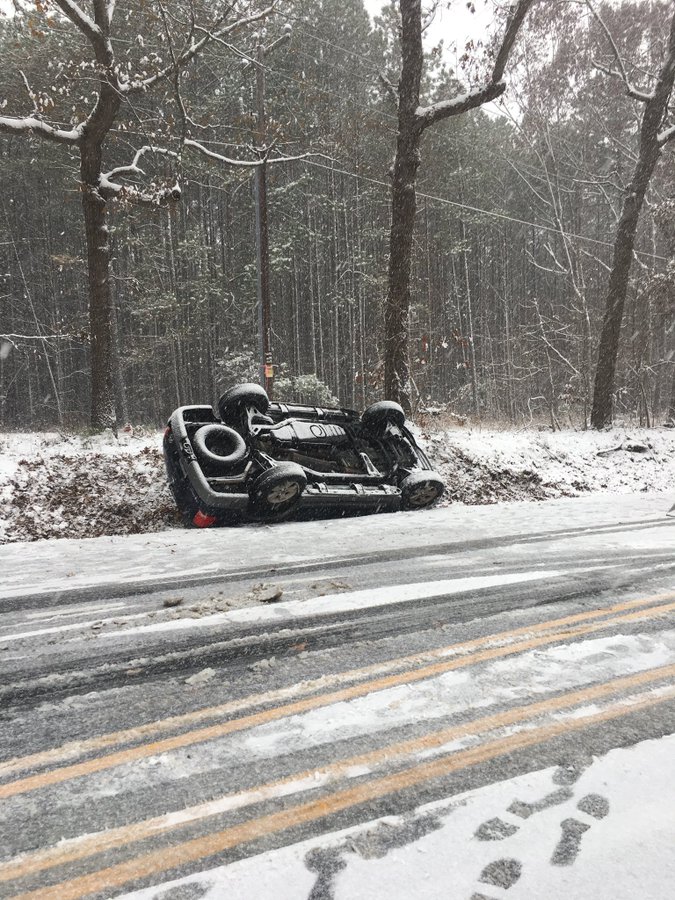
Now the South is digging out.
More than 276,000 people still were without power across seven states as of Monday morning -- with over half of those in North Carolina.
In Virginia, state police said they responded to over 1,000 car crashes on Sunday.
The major winter storm that just pummeled the Southeast brought 2 feet of snow to Whitetop, Virginia, and up to 20 inches of powder in North Carolina.
Richmond, Virginia, had its second-snowiest December day on record and double-digit totals were reported in South Carolina, Tennessee and as far west as Texas.
Parts of West Virginia saw 20 inches of snow. Even Georgia got 8 inches.
View image on Twitter

Lieutenant Cimbal@LtCimbal046
Once again I am asking drivers to slow down. We r working several crashes due to drivers misjudgment of road conditions. #DriveSafely #SlowDown @CCPDVa no injuries seatbelts save lives!
46
11:00 AM - Dec 9, 2018
Now the South is digging out.
More than 276,000 people still were without power across seven states as of Monday morning -- with over half of those in North Carolina.
In Virginia, state police said they responded to over 1,000 car crashes on Sunday.
_________________


8DonCo
 Similar topics
» Seattle area blanket with snow
» B.1.351 (South Africa)
» Nhà hàng South Cali
» Chicago to South or East Asia from $378
» Ice storm hits the South and central US
» B.1.351 (South Africa)
» Nhà hàng South Cali
» Chicago to South or East Asia from $378
» Ice storm hits the South and central US
Page 1 of 1
Permissions in this forum:
You cannot reply to topics in this forum
 Home
Home
